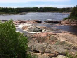
The 378-kilometre-long river flows south from the Labrador-Quebec border through the Minganie RCM into the Gulf of St. Lawrence. It is fed by some thirty tributaries and drains an immense watershed of over 16,000 square kilometers. Throughout its course, rugged sections alternate with calm waters, allowing us to appreciate its considerable size. The last 18 kilometers form a wide estuary dotted with sandbanks, beaches and a multitude of islands. This splendid river is one of the region’s most beautiful spots for canoeing and kayaking expeditions.
The Natashquan has been a renowned salmon river since the 18th century. In 1984, its first 48 kilometers were ceded to the Natashquan Band Council. It founded the Hipou outfitting operation to manage sport fishing in a section of the river stretching from kilometer 14 to kilometer 42. The salmon that swim up its dark waters, punctuated by several impressive waterfalls, have an average weight of around three kilos. There are some 30 pools spread over three fishing sectors.
Access
Access via the municipality of Natashquan, where you’ll find many services: camping, inns, B&Bs, restaurants, outfitters, etc.
Its original Innu name, Nutahquaniu Hipu, means “river where the black bear is hunted”.

User Reviews
Write a reviewBe the first to write a review.