The Gabrielle-Roy-Est trail leads to the summit of Mont Grabrielle-Roy. Whichever direction you take, you’ll be treated to magnificent 360° views of the region: the mountains of Parc national des Grands-Jardins and Hautes-Gorges-de-la-Rivière-Malbaie, Mont Grand-Fonds, Mont des Éboulements, Isle-aux-Coudres, Île-aux-Grues, Massif du Sud and Massif de Charlevoix.
The Louise-Gasnier trail links the Grabrielle-Roy-Est and Grabrielle-Roy-Ouest trails. The easy trail offers a number of viewpoints and two superb suspension footbridges. These span the Rivière Du Sault several times, allowing you to admire the surrounding countryside.
Gabrielle Roy, a French-Canadian author who grew up in Manitoba, spent 25 summers in the Charlevoix region. She drew inspiration for her writing from the landscapes and waterways. Petite-Rivière-Saint-François remained her favorite spot.
Access West
The parking lot is located at the corner of Route 138 and Rue Principale in the village of Petite-Rivière-Saint-François.
East access P4
Located at 411 chemin de la Martine in the village of Petite-Rivière-Saint-François (parking lot not cleared of snow in winter).
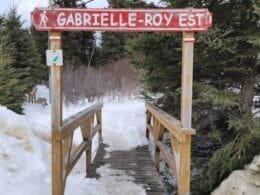
East access
Charlevoix tourist information office, 444 boulevard Mgr-De-Laval, Baie-Saint-Paul

User Reviews
Write a reviewBe the first to write a review.