Lake Opasatica
Located 25 km northeast of Rouyn-Noranda – Montbeillard, this lake lies along the Ontario border, at the northern limit of the Ottawa River watershed. With a length of 34 km, it is up to 6 km wide in the northern part and tapers to less than 1 km at the southern end, where Solitaire Bay is located.
It’s a popular boating destination, thanks in part to its 60-metre depths and proximity to Rouyn-Noranda. Sea kayaking here takes on a more serious dimension than in most enclosed waters, especially when a breeze picks up and waves are born.
During the fur trade era, Lake Opasatica was an essential waterway linking the St. Lawrence to Hudson Bay. In fact, several thousand Amerindian artifacts have been discovered here by the Archéo 08 group.
Opasatica trails
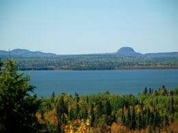
Located between Baie Verte and Baie de l’Orignal, the hiking trails consist mainly of three parallel paths that run along the southern flank and crest of a rocky massif. The trails are marked and equipped with rest areas and lookouts offering panoramic views of the surrounding area and Opasatica Lake.
The terrain is mountainous, with good gradients. The vegetation is unique to the region, with large pine, spruce, cedar and yellow birch trees. The trails are also used in winter for snowshoeing.
Access
To get there from Rouyn-Noranda, take Route 117 west. After the village of Anrtfield, head south on Route 101 towards Ville-Marie. Follow this road 6.3 km to rue de la Baie Verte. Drive another 1.6 km, and the first parking lot is on your left. If you continue on Rue des Amis, you’ll find the second parking lot at the end of the road.
Of Algonquin origin, the name Opasatica, recorded since the early 20th century, is thought to be formed from Obié or Opa, meaning shrunken, and Satika, translated as “there are aspens”.
Depending on the source, we get “lake surrounded by poplars”, “poplar strait” or “lake closed by aspens”.

User Reviews
Write a reviewBe the first to write a review.