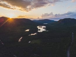
The Lac-au-Sable ZEC features the typical relief of the Charlevoix landscape.
Elevations range from 150 m to over 1000 m.
The zec’s exceptional vantage points are a true reflection of Quebec.
In the Zec’s territory, a hundred or so lakes, including a dozen large ones, nestle in the hollows of the valleys.
A network of rivers criss-crosses the territory, providing numerous opportunities for recreation.
The entrance to its territory near Clermont has a network of well-maintained, easy-access roads that don’t require private vehicles.
The activities
Fishing: brook trout and/or Arctic char.
Hunting: White-tailed deer, pheasant, grouse, hare, moose, black bear and grouse.
The ZEC has 3 hiking trails: the Mont Élie trail 8 km (allé) of intermediate/advanced difficulty, the Menaud trail 7.6 km round trip and the Gamelle trail less than 2 km round trip.
The latter follows a river and offers a view of the beautiful Gamelle waterfall.
Lac au Sable boasts a magnificent sandy beach for swimming.
It is close to the Élie and Menaud hiking trails.
Available for rental: rowboat, kayak and paddleboard.

User Reviews
Write a reviewBe the first to write a review.