At 984 meters, Parc national des Monts-Valin dominates the landscape of the Saguenay-Lac-Saint-Jean region. Brook trout fishing and canoeing can be enjoyed on many of the park’s lakes and rivers. In addition to canoeing, paddleboarding is an original way to explore the meandering Valin River.
In autumn, hiking is the order of the day, with overnight stays in mountain huts. In winter, exceptional snow conditions transform the area into a paradise for snowshoeing and Nordic skiing.
PEAK HIKING
This scenic route has been designed to provide access to the park’s peaks and summits, which overlook some truly exceptional scenery. With a vertical drop of 755 metres and a total length of 22 kilometers (one way), it crosses the entire park territory.
DAY FISHING
Put your line in the water for the day and tease the brook trout! The lakes for day fishing are Lac Antoine, Lac Culotte and Lac Martin-Valin. Several boats are available on these lakes. Lodging packages are also available in summer.
NINE BLUEBERRIES FOR ONE TART
Discover the impact of altitude on flora and fauna. All the gourmets in the world will be happy to learn that a dozen varieties of blueberry can be found on the summits… From August 13 to the first snowfall, at Pic-de-la-Hutte.
Discover the Valin River
Paddle the Valin River and discover its wealth of flora and fauna. At the foot of the imposing massif, explore the river’s many sinuosities and enjoy an unparalleled view of Mont Valin. To make the most of your experience, pick up a free brochure from the Discovery and Services Centre.
Schedule: daily, June to October (water levels permitting)
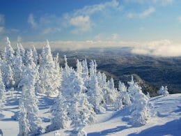
Winter hiking trails
Heavy snowfalls make this park a particularly interesting site for snowshoers. There are more than a dozen short hikes to discover different areas and points of interest in the park. The Tête-de-Chien trail is a great target for a half-day hike.
The Nordic ski trail network extends over 65 kilometers, while the snowshoe trail network covers more than 71 kilometers. These trails are marked, but not groomed. Most are shared by both Nordic skiers and snowshoers. Long-distance hikers should plan their itinerary carefully, taking into account the availability of mountain huts and rustic camps. Book early! Luggage transport, tracked vehicle transport and refuelling services are available to enhance your experience.

User Reviews
Write a reviewBe the first to write a review.