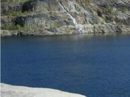
Located in the municipality of Sacré-Coeur-de-Jésus, the Miners’ Trail lets you explore the site of the two former Boston and Carey mines. It’s one of the few places where nature has reclaimed its rights, thanks to the natural reclamation of mine tailings that bear witness to the history of the greater Amiante region. Two huge mine shafts have become large lakes, one of which is fed by a superb waterfall, while the other offers an unforgettable view of the turquoise-blue water.
There are three easy-to-intermediate trails totalling 7.8km. They pass through deciduous forest, over soil often composed of excavation residues, and a few mountains formed from these same mine tailings. Two lookouts offering views of the mine shafts and nearby peaks and villages will satisfy those in search of a spectacular panorama. There are also historical, geological and wildlife self-interpretation panels, as well as an artistic picnic area with unusual sculptures and poems.
In winter, the Miners’ Trail network is transformed into cross-country ski trails. These are laid out and maintained by the La Balade cross-country ski and snowshoe club.

User Reviews
Write a reviewBe the first to write a review.