Sentiers des Collines d’Alembert
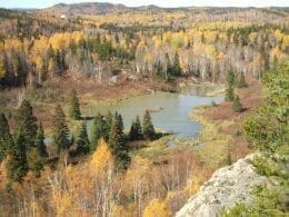
Located west of the village of Alembert, the hiking trails are accessible in summer and winter for snowshoeing. There are 7 trails in the hills, ranging from easy for beginners to expert for the more adventurous. Along the way, you’ll see interesting geological formations such as volcanic pillows and quartz veins.
Many trailheads offer panoramic views of magnificent landscapes. Interpretation panels explain the ecological, wildlife and geological aspects of the hills.
Access
From Rouyn-Noranda, follow Route 101 North for 15 km towards d’Alembert.
- Once in the village, turn left onto rue Harrisson. Parking is located before the curve.
- When you reach the village, turn left and drive about 500 m along Chemin des Pins. The trailhead is next to the parking lot.
Features
- Length of network on foot: 9 km
- Length of snowshoe network: 7 km
- Number of walking trails: 7
- Number of snowshoe trails: 6

User Reviews
Write a reviewBe the first to write a review.